Hiking
Hiking in Idyllwild starts at the edge of the village and climbs into the San Jacinto Wilderness. Some trails need nothing but water. The wilderness trails need a free permit, and this page says which.
- Permit
- Required, wilderness trails
- Parking
- Adventure Pass at Humber
- Water
- None at trailheads
Trail and permit details come from the San Jacinto Ranger District and Mount San Jacinto State Park.
Map
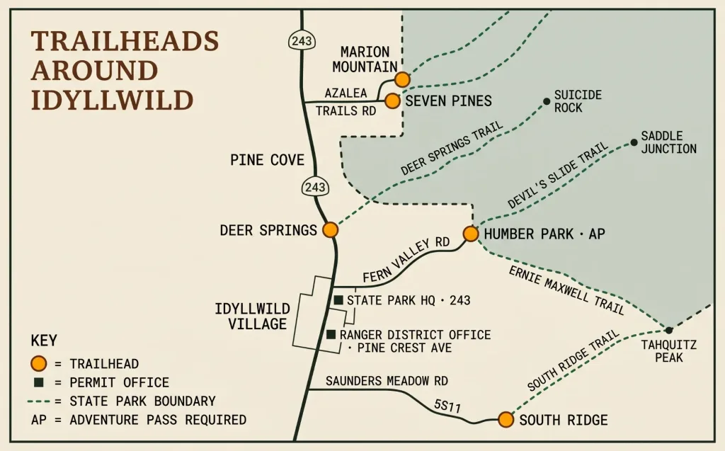
Humber Park, above the village: Devil's Slide and Ernie Maxwell; Adventure Pass required. Deer Springs: Highway 243, 1 mile north of town; no pass. Marion Mountain and Seven Pines: Azalea Trails Road off Highway 243, about 5 miles north. South Ridge: Saunders Meadow Road to forest road 5S11. Permits: San Jacinto Ranger District, 54270 Pine Crest; State Park headquarters, 25905 Highway 243.
How hiking works here
This is a hiking town. From Humber Park, just above the village, you can walk to the top of San Jacinto Peak, the highest point in California’s state park system, or spend an easy morning under the pines on Ernie Maxwell.
Idyllwild sits at about 5,400 feet at the foot of the San Jacinto Mountains, and our trails go two ways: up into the San Jacinto Wilderness toward the peak, or out along the lower ridges and valleys, where the rules are lighter. Knowing which kind you’re on is most of the planning.
Trails into the San Jacinto Wilderness need a free permit, day hike or overnight. Each trail below says whether it does, and the Permits and trail rules box says where to get one. Dogs are fine on a leash in the national forest and not allowed in the state park wilderness.
Distances and elevations here come from the Forest Service and the State Park. Forest Service distances are one way unless we say otherwise; the State Park gives round trips, and we say so each time. Where the two agencies’ numbers differ, we give both.
From Humber Park
Humber Park, above the village, is the main trailhead on the Hill and the start of the two best-known trails. Parking there needs an Adventure Pass, and there is no drinking water at the lot. The lot fills up early on weekends; either head out at dawn or plan a hike later in the afternoon when the early birds have left.
Humber Park · 2.5 mi · Permit required
Devil’s Slide Trail
The classic way up the mountain. Devil’s Slide climbs about 1,700 feet in 2.5 miles of switchbacks to Saddle Junction, and the valley opens up behind you as you go. The Forest Service rates it moderate.
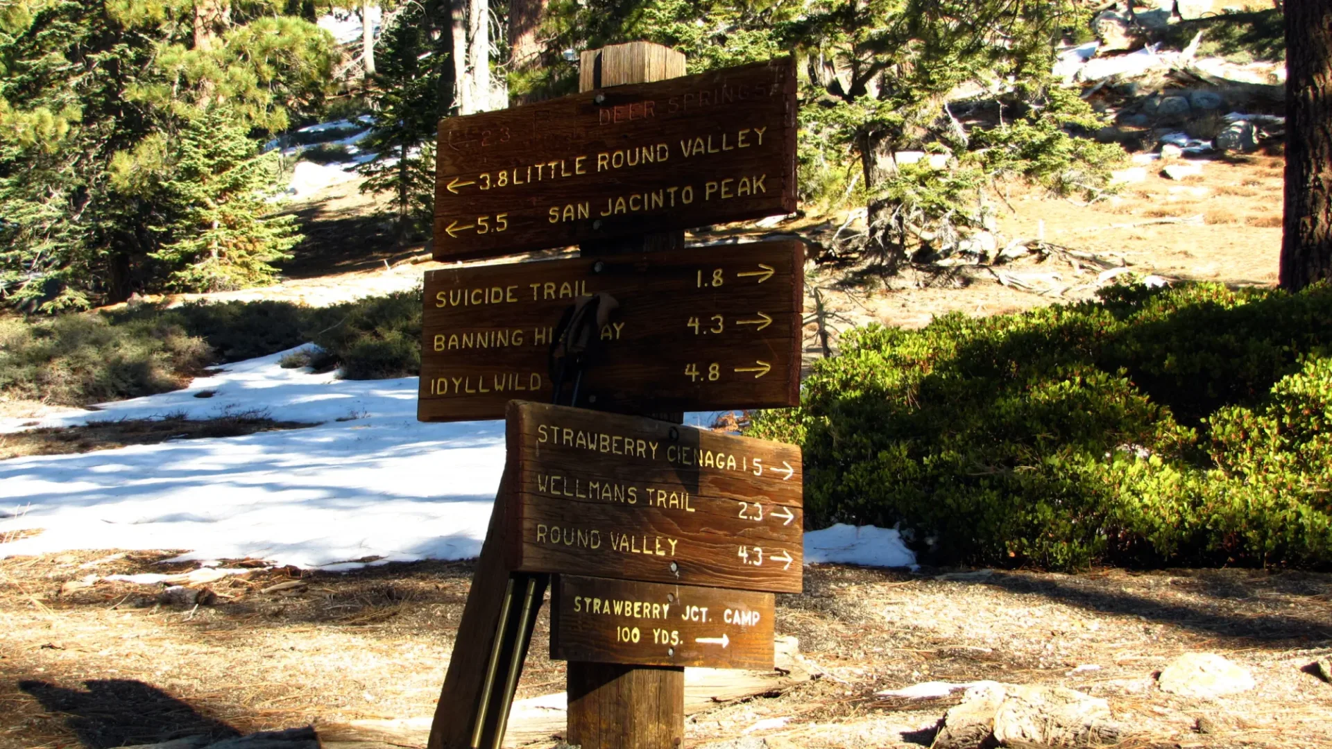
Saddle Junction is a crossroads. The Pacific Crest Trail passes through, and trails lead on to Tahquitz Peak and its fire lookout, to San Jacinto Peak, and across to Long Valley at the top of the Palm Springs Aerial Tramway. The State Park puts the full trip from Humber Park to San Jacinto Peak at 16 miles round trip with 4,500 feet of gain, and to Wellman Divide at 10.6 miles round trip with 3,300 feet of gain.
Summer weekend permits are limited; see Permits and trail rules below.
Humber Park · 2.6 mi · Rated easy
Ernie Maxwell Scenic Trail
The gentle one. Ernie Maxwell runs 2.6 miles from Humber Park to a dirt road at Tahquitz View Drive, starting around 6,400 feet and dropping about 700 feet through the pines, crossing small streams on the way. The Forest Service rates it easy, and it’s a good walk for anyone who likes to put names to trees. Bikes aren’t allowed. About a quarter mile along, a steep climbers’ trail branches up to Tahquitz Rock (see Rock climbing).
Fill out a free day permit at the kiosk outside the ranger station; it takes a minute.
North of the village
Highway 243 · 1 mi north of town · Permit required · No dogs
Deer Springs Trail and Suicide Rock
Deer Springs starts on Highway 243 about a mile north of Idyllwild, at 5,600 feet, and you don’t need an Adventure Pass to park there. At the 2.3-mile junction, a 1-mile cutoff branches right to the top of Suicide Rock (7,528 feet), with the village below and Tahquitz Rock across the valley. The State Park lists the Suicide Rock hike at 6.6 miles round trip with 1,900 feet of gain.
Keep going and Deer Springs becomes the long way to San Jacinto Peak: 18.4 miles round trip and 5,300 feet of gain by the State Park’s count.
Leave the dog at home for this one. The Forest Service closes the whole Deer Springs Trail to dogs, Suicide Rock included.
Azalea Trails Road · 5 mi north of town · Permit required · No dogs
Marion Mountain Trail
The shortest route to San Jacinto Peak, and the steepest. Marion Mountain starts at 6,480 feet on the road to Marion Mountain Campground: take Azalea Trails Road off Highway 243 at the Alandale Fire Station, about 5 miles north of town. It climbs 2,300 feet through heavy forest to meet the Deer Springs Trail. The State Park counts the whole trip to the peak at 10.6 miles round trip with 4,500 feet of gain. The Forest Service rates it strenuous and says no dogs.
Seven Pines Trail
Seven Pines follows the North Fork of the San Jacinto River up to its source at Deer Springs, heavily forested, with plenty of switchbacks. The district’s trail guide puts the start at 6,320 feet, with 2,300 feet of climbing to the Deer Springs Trail. You reach it through Dark Canyon Campground. The access road and the trail itself can be in rough shape, so check the Seven Pines page for current conditions before you plan on it.
Black Mountain Road · High clearance · Permit required
Fuller Ridge Trail
Part of the Pacific Crest Trail. Fuller Ridge starts at 7,600 feet off Black Mountain Road (4S01) and follows a high, timbered ridge above Snow Creek, with long views over the desert. It meets the Deer Springs Trail at 9,200 feet, and from there it’s 2.5 steep miles to San Jacinto Peak. The Forest Service recommends four-wheel drive with high clearance for the road. Its trail guide gives June to October as the season, with the road usually closed from November to May.
Highway 243 · Black Mountain · No permit required
Black Mountain Trail
Permits aren’t needed for a day hike. Black Mountain leaves Highway 243 1.3 miles south of the Vista Grande Fire Station and climbs 3.6 strenuous miles, from chaparral at 4,480 feet to the forested slopes of Black Mountain at 7,772 feet, with views across Banning Pass to Mount San Gorgonio.
South of the village
Saunders Meadow Road · Road 5S11 · Permit required
South Ridge Trail to Tahquitz Peak
South Ridge climbs to the fire lookout on Tahquitz Peak, with the Desert Divide, Strawberry Valley and beyond spread out below. Follow the signs on Saunders Meadow Road to forest road 5S11. From the upper trailhead on 5S11, the district’s trail guide puts the start at 6,800 feet with about 2,000 feet of climbing. Start lower, at Tahquitz View Drive, and the Forest Service counts 4.1 miles and about 2,400 feet to the lookout junction at 8,850 feet. It’s rated moderate.
In summer, go in the morning. The ridge gets warm and dry later in the day. If the dog came along, check your map for the state park boundary.
Webster Trail
Webster drops 2.5 strenuous miles west from forest road 5S10 to the North Fork of the San Jacinto River. It starts at 5,400 feet and loses 1,800 feet, over a ridge and through pine, cedar and chaparral to streamside willows, with views over the San Jacinto and Hemet valleys. Every foot of that comes back on the way out.
Highway 74 · West of Mountain Center
South Fork Trail
South Fork runs 4.5 moderately strenuous miles from Highway 74, at 3,800 feet, down to the South Fork of the San Jacinto River, then up to 4,600 feet at Rouse Ridge Road. Park at the Caltrans cinder bin turnout on Highway 74 west of Mountain Center. The trail is the way in for fishing the river. The district’s older trail guide lists it as a non-wilderness trail, but the area became the South Fork San Jacinto Wilderness in 2009. [VERIFY: whether South Fork Trail now needs a wilderness permit]
Garner Valley and the Desert Divide
Southeast of town, Highway 74 runs through Garner Valley, and a string of trails climbs from it to the Desert Divide and the Pacific Crest Trail. They start lower than the Humber Park trails, in chaparral and oak, and they get warm in summer.
Pacific Crest Trail
The PCT runs 57.6 miles through this district, from Highway 74 in Garner Valley (PCT mile 151.9) to Interstate 10 near Cabazon (mile 209.5), and 28 of those miles are inside the San Jacinto Wilderness. Hiking the wilderness sections needs a permit; long-distance hikers carrying a valid PCT permit don’t need a separate one. No bikes anywhere on it.
Highway 74 · 3.5 mi south of Lake Hemet · No permit
Ramona Trail
A moderate 3 miles one way. Ramona starts off Highway 74 near Kenworthy, about 3.5 miles south of Lake Hemet, at 4,400 feet, and climbs 1,500 feet to Toolbox Spring on Thomas Mountain Road (6S13), with views over Garner Valley. It’s open to hikers, horses and mountain bikes, and no permit is needed.
Fobes Trail
A moderate 1.5 miles from the end of Fobes Ranch Road (6S05), through chaparral and oak to the Pacific Crest Trail. It starts at 5,200 feet and gains 800. It’s a good way to reach Spitler Peak and Palm View Peak along the divide.
Cedar Spring Trail
The trail begins on Morris Ranch Road, 4 miles north of Highway 74, and crosses private property, so stay on the dirt road. It’s a moderate 3.2 miles from 5,760 feet to the Pacific Crest Trail at 6,400 feet, south of Palm View Peak. Cedar Spring is another mile on: cross the PCT and continue northeast.
Spitler Peak Trail
A strenuous 5 miles from Apple Canyon Road in Garner Valley, climbing 2,040 feet from 4,920 feet to about 7,000 feet, where it meets the PCT north of Spitler Peak. It goes from chaparral up into oaks and pines and can be warm in summer. Spitler Peak is one of the seven wilderness trailheads, so bring a permit.
Farther out
The district lists more trails farther from town, among them Cahuilla Mountain near Anza, Palm Canyon toward Palm Springs and Cactus Spring in the Santa Rosa Wilderness. Check the San Jacinto Ranger District’s trail guide for where each one starts and what it needs.
From the top of the tram
The Palm Springs Aerial Tramway lifts you from the desert floor into Long Valley, inside the state park wilderness, and several trails start there, including another way up San Jacinto Peak. Mount San Jacinto State Park lists them with distances, and the Long Valley Ranger Station issues day permits.
Before you set out
Water. Carry all you need. There’s none at Humber Park or at most trailheads, and the Forest Service says to treat any water from an open source by filtering, tablets or a rolling boil.
Rattlesnakes. They’re out from spring through fall. Watch where you put your hands and feet, stay on the trail, and keep your dog on its leash.
No signal. Cell service out there is spotty or nonexistent. Tell someone where you’re going and when you’ll be back; the Forest Service suggests the same. On the long routes, a personal locator beacon is worth carrying.
Weather and trail conditions. The high country gets real mountain weather, including heavy rain and snow, and the peak can be in winter when the village isn’t. Check Weather & Roads before you drive up, check the trail’s own Forest Service or State Park page for closures, and pack layers.
The essentials. The Forest Service’s list: map and compass, extra clothing, extra food and water, first aid kit, headlamp with spare batteries, matches and fire starter, knife, sunglasses, sunscreen, water filter and whistle.
10,834 FEET AT SAN JACINTO PEAK, TOP OF THE STATE PARK SYSTEM
San Jacinto Peak is the highest point in California's state park system, and you can walk to it from trailheads above the village. Marion Mountain is the shortest way up; Devil's Slide and Deer Springs are the classics.
Permits and trail rules
Which trails need a permit
Every day hike and every overnight trip into the San Jacinto Wilderness needs a free wilderness permit. From the Idyllwild side, that means seven trailheads: Deer Springs, Devil’s Slide, Marion Mountain, Seven Pines, South Ridge, Spitler Peak and Fuller Ridge. You need it wherever you plan to turn around. The state park wilderness around San Jacinto Peak needs a permit too, and the two agencies honor each other’s day-use permits.
One permit covers your whole group. Keep your copy with you on the trail.
Quotas and booking windows change, so check with the San Jacinto Ranger District for the national forest and Mount San Jacinto State Park for the state wilderness.
Devil’s Slide on summer weekends
On summer weekends the Forest Service limits how many day permits it issues for Devil’s Slide, and those permits come from Forest Service staff: you can’t self-issue one at the kiosk or apply online, and a State Park permit won’t do. If you have your heart set on a summer Saturday, check availability and how to reserve with the ranger district well before you drive up. The limit is a weekend one, so a weekday hike is the usual way around it.
If your day is full, pick another trailhead. Deer Springs, South Ridge and Marion Mountain all climb into the same wilderness from our side of the mountain.
Where to get a permit
- Online. The Forest Service Volunteer Association, which staffs the Idyllwild station, takes day permit applications for the national forest wilderness, except Devil’s Slide summer weekend permits.
- San Jacinto Ranger District, 54270 Pine Crest, in the village. There’s a self-issue kiosk outside for when the office is closed. Office hours vary, so check the district’s page before you count on talking to a ranger.
- Mount San Jacinto State Park headquarters, at the Idyllwild Campground entrance, 25905 Highway 243. Day permits on the porch.
- Stone Creek Campground, north of town. Day permits on the porch in season.
- Long Valley Ranger Station, at the top of the Palm Springs Aerial Tramway.
To use one: fill it out, drop the original in the box, and carry the copy.
Camping overnight in the wilderness
Overnight permits are where the two agencies part ways. Each issues its own, and neither honors the other’s. If your route camps in both, you need both. Both agencies take applications ahead of time, and each one’s permit page has the current fees, booking windows and how to apply. Our camping guide covers the camps themselves.
Adventure Pass and trailhead parking
Parking at Humber Park, Lake Fulmor, Fuller Mill Creek and the Forest Service day-use area at Lake Hemet needs a recreation pass on your dashboard or hanging from the mirror: a National Forest Adventure Pass, or an America the Beautiful interagency pass. Buy it before you get to the lot, from the ranger station, a local vendor or as a digital day pass on Recreation.gov. The Forest Service’s Adventure Pass page has current prices and vendors. The Deer Springs trailhead doesn’t need one, and you don’t need one to drive through the forest or stop for a photo.
Dogs
In the national forest, wilderness included, dogs must be on a leash no longer than 6 feet. In the state park wilderness, dogs aren’t allowed at all, service animals excepted, and that includes San Jacinto Peak and the tram. Some trails cross from one to the other. The Forest Service closes the whole Deer Springs Trail to dogs, Suicide Rock included, and Marion Mountain too. On the rest, check your map for the state park boundary before you bring the dog. Idyllwild with dogs has the walks that work.
Fires and stoves
Campfires aren’t allowed in the wilderness, and stoves need a free California Campfire Permit. Fire rules are set by the Forest Service and the State Park and change with conditions, so check with them before you go.
Leave No Trace
We ask you to follow Leave No Trace on every trail here, and in the wilderness most of it is the rule. Keep groups to 12 or fewer. Camp on a durable surface at least 200 feet from other people, trails, meadows and water. Pack out everything you pack in. No bikes, hang gliders or motorized equipment. Where a trail crosses private land, as on the Cedar Spring approach, stay on it. Leave rocks, plants and artifacts where you found them. It’s all we have.
Keep going